References
Hamburg quay wall

Project Data
Client
Public port operator in Northern Germany
Project Period
2019 and 2022
Project Scope
Survey of a quay wall and its wooden pile foundation running approx. 200 m in length
Scope of Services
Underwater survey of the quay wall and riverbed/seabed (HydroScan)
Above-water survey of the quay wall (HD Mapping)
Above-water drone survey of the port area (AeroVision)
Data processing
Data delivery
—————
Introduction
As part of the damage analysis and rehabilitation planning for a quay facility owned by a public port operator in Northern Germany, HydroMapper executed a high-resolution underwater survey of the affected port structure. The focus of the mission was the digital capture of a complex quay wall section featuring several rows of historic wooden piles, as well as highly confined, difficult-to-access underwater zones.
The survey was carried out under challenging environmental conditions, including limited visibility, complex geometries, and structural elements partially buried in sediment. By deploying a combined payload of state-of-the-art HydroScan and HD mapping technologies, we successfully generated a precise digital twin of the port facility. The acquired data assets deliver an invaluable foundation for technical assessment and subsequent rehabilitation engineering.
Initial Situation
The project was triggered by a structural failure along a quay wall section in a Northern German port, which required partial closure of the facility. Since the underwater conditions were largely unknown prior to the survey, there was a critical need for a highly accurate and comprehensive as-built capture of the affected structural components.
The objective of the campaign was to deliver a reliable data foundation for the upcoming rehabilitation design while comprehensively documenting the existing structural assets, including the historical wooden pile foundations.
Our Engineering Approach
To capture the as-built conditions digitally, we deployed a multi-sensor survey approach, capturing both the submerged components and the visible above-water structures in high resolution.
The deployed setup included:
Surveying via the HydroMapper survey vessel
HydroScan technology to generate high-precision underwater point clouds
HD mapping using terrestrial scanning and modern photogrammetry pipelines
Post-processing and sensor fusion of all datasets into a single, consistent digital model
By combining these diverse sensor technologies, even the highly complex structural features and pile arrangements were captured and analyzed with high precision.
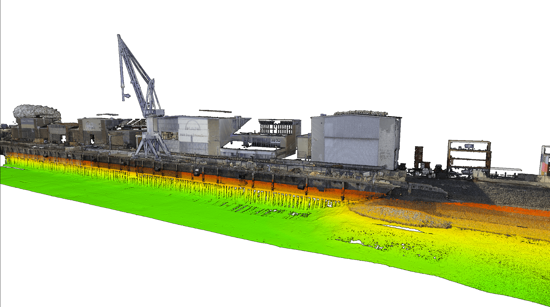
From Physical Structure to Digital Twin
The underwater mapping was executed using high-precision hydroacoustic scanning (HydroScanning), enabling detailed digital capture of complex geometries and hard-to-reach areas. To complement this, all structural elements above the waterline were surveyed using terrestrial laser scanning and drone-based photogrammetry.
The result is a complete, georeferenced three-dimensional model of the port facility—including the visible sections of the quay wall, adjacent warehouse structures, and roof surfaces. Integrating these datasets provided a seamless, holistic view of the engineering infrastructure across both wet and dry domains.
These high-resolution point clouds and 3D models provide an exceptionally precise digital basis for downstream engineering analysis, planning, and future structural interventions.

Empowering Data-Driven Decisions
The generated datasets enabled the appointed engineering office to perform a highly accurate structural assessment and build their rehabilitation design on a robust foundation. Thanks to the high geometric fidelity of the spatial data, target-performance comparisons were executed, and structural deviations were precisely mapped and analyzed.
Additionally, the digital as-built data enabled highly accurate material and volume calculations for upcoming construction phases. At the same time, the integrity of the adjacent quay wall sections could be assessed, identifying potential structural risks early in the process.

This digital data package streamlines planning workflows, enhances cost predictability, and supports engineering teams in making sound technical decisions.
Outlook and Downstream Lifecycle Value
The pile structure data captured during the survey provides significant value far beyond the scope of the immediate rehabilitation work. Most notably, the high-resolution spatial models will serve as the baseline for future spatial conflict analysis (clash detection) between planned anchoring systems and existing wooden piles.
Furthermore, this digital asset serves as a long-term resource for future structural integrity inspections, engineering updates, and infrastructure maintenance planning.


