References
Traffic and Parking Areas Bremerhaven

Project Data
Client
BLG LOGISTICS GROUP AG & Co. KG
Project Period
18.12.2024 - 31.05.2025
Project Scope
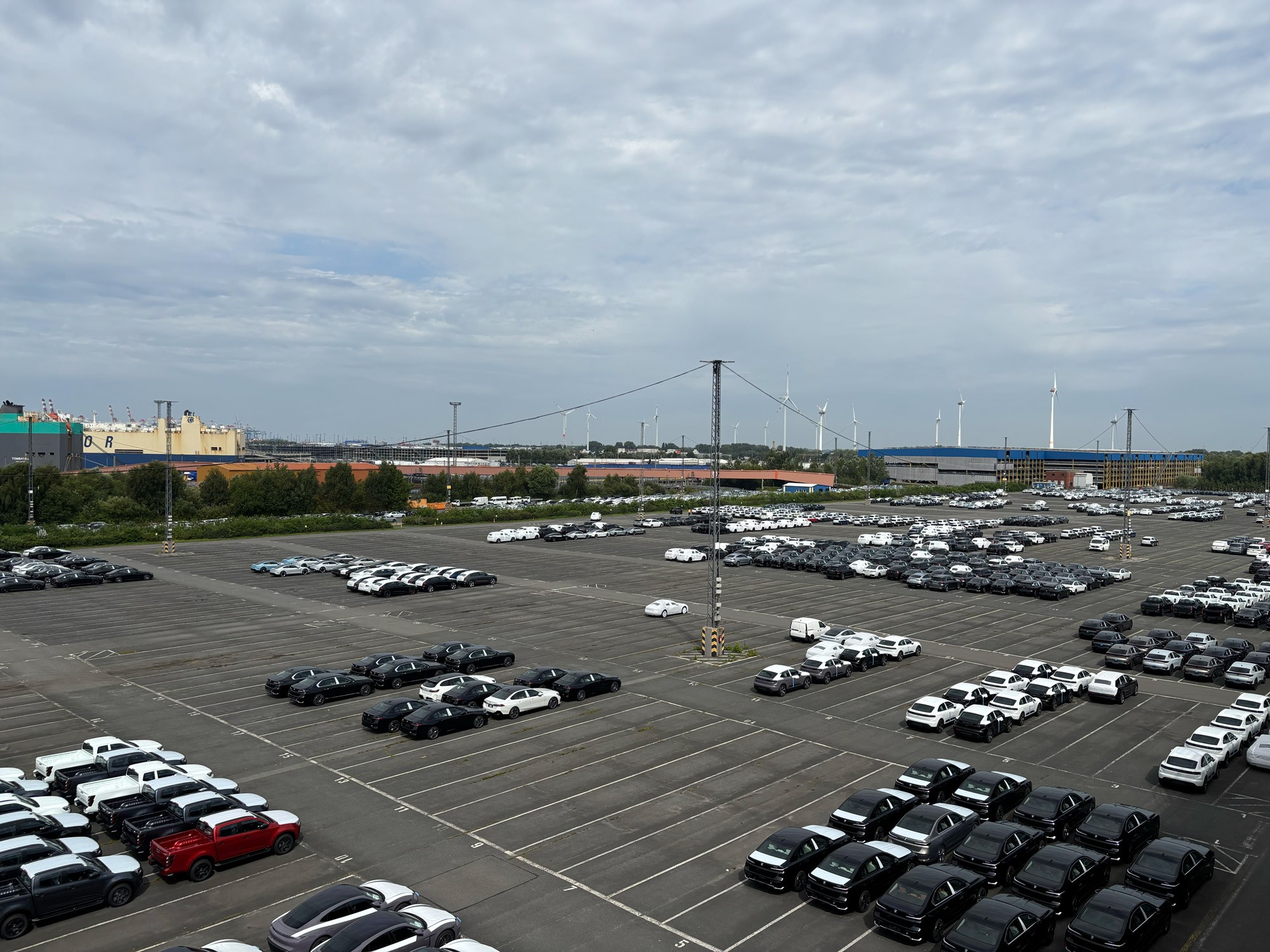
Digital current-state survey and AI-powered damage analysis of a 75,000 m² traffic and parking area at the Bremerhaven Automotive Logistics Center
Scope of Services
Drone and mobile mapping technology for comprehensive spatial acquisition
Integration of measurement data into the InfraCloud
Automated damage detection in accordance with E EMI 2012 guidelines
Classification and visual representation according to condition classes
Filtering, prioritization, and cost estimation of maintenance measures
Elevation profile analysis and drainage evaluation
———————
Introduction
BLG LOGISTICS operates one of the largest automotive logistics centers in Europe in Bremerhaven. Heavy weathering and high surface traffic led to increasing wear and tear on traffic and parking areas – with rising risks for operational safety and unplanned maintenance costs.
Deploying InfraCloud enabled the transition from reactive repairs to proactive, data-driven infrastructure management: damages are detected and assessed early and seamlessly transferred into a structured action plan.

Initial Situation
Damage to the traffic and parking surfaces was often only noticed when immediate action became unavoidable. Preventive planning was virtually impossible because inventory data was incomplete and damage patterns were not recorded systematically.
This resulted in three key problems: a lack of a valid data foundation, a reactive instead of preventive approach, as well as increased costs and safety risks during ongoing operations.
Our Approach
A 75,000 m² parking area was fully surveyed using drone and mobile mapping technology. The acquired measurement data was integrated directly into our cloud-based InfraCloud platform.
Once uploaded, the software automatically detected damage according to the E EMI 2012 standard, classified it, and visualized it color-coded by condition class. Engineers could then filter, prioritize, and generate cost estimates with just a few clicks – for the first time based on complete, high-integrity data.
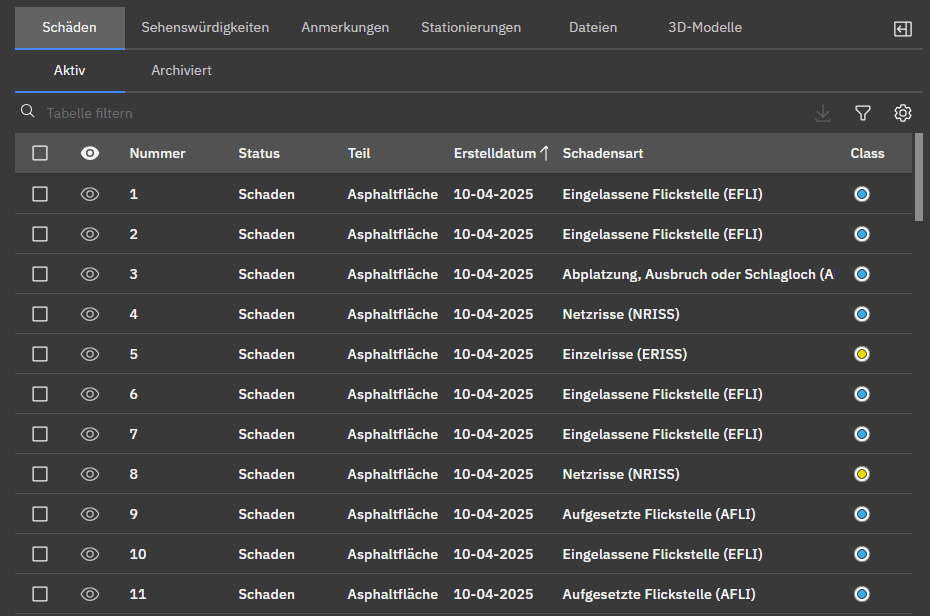 | 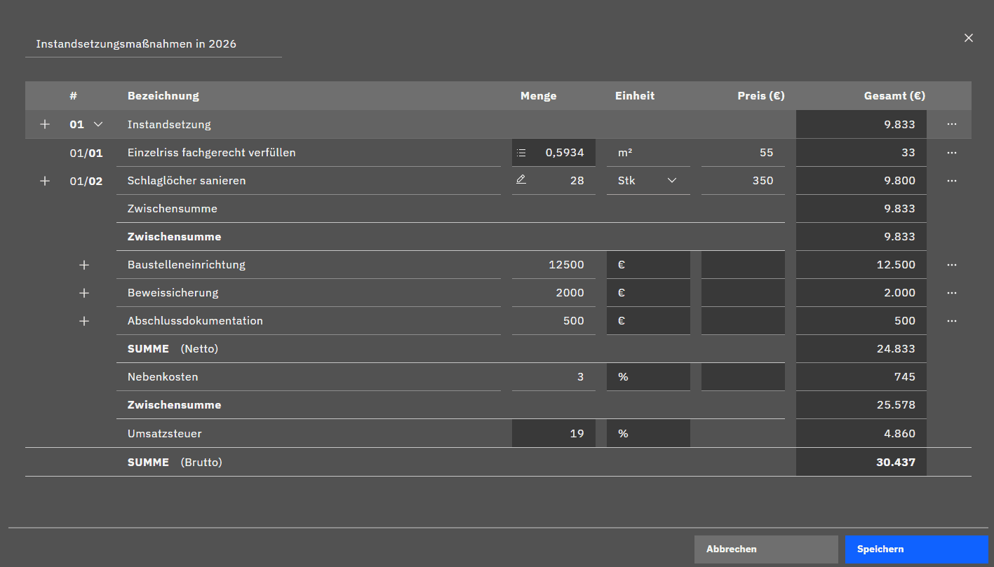 |
The platform displays all detected damages in a detailed list view. Engineers can filter, sort, and prioritize maintenance measures – for the first time based on complete, reliable data. | With just a few clicks, InfraCloud generates reliable cost assumptions for retrofits. This provides high planning security, supports budgeting, and enables a transparent, proactive maintenance strategy. |
From Asset to Digital Twin
The spatial capture resulted in a seamless digital twin of the entire traffic and parking area. Every single defect was logged in a detailed inventory list, color-categorized by condition class, and linked directly to the spatial dataset.
In addition, InfraCloud enables powerful analysis: the elevation profile view allows engineers to spot and flag potential water pooling and drainage system defects within seconds. Highlighted rainwater inlets make critical weaknesses visible at a glance.

The Foundation for Solid Engineering Decisions
BLG has evolved its approach from reactive maintenance to proactive, data-driven management. Potential risks are identified early, improving operational safety and budget planning reliability.
With just a few clicks, InfraCloud creates solid cost estimations for repairs – the core building blocks for a transparent, predictable maintenance strategy. For the first time, the platform delivers the tools required for long-term, climate-resilient asset management.
Impact in Numbers
Early detection of critical damage
Reduced maintenance and repair costs
Enhanced operational safety
Foundation for long-term climate-resilient planning
Testimonial
"In the past, we worked with a 2D rehabilitation plan – now we can map our infrastructure in 3D. This brings an enormous leap in quality and data depth, leading to much more informed decisions." — Nils Herzog, Project Manager, BLG AutoTec GmbH
Outlook and Future Application
In partnership with HydroMapper, BLG is currently working on advancing the platform further – aiming for even more precise remaining useful life (RUL) predictions and optimized drainage planning.
The gathered data now acts as the foundation for continuous monitoring of the paved infrastructure, providing an objective, data-driven basis for future maintenance and climate adaptation measures.


