Structure Mapping

HydroScan - Patented Underwater Surveying Technology

With HydroScan, HydroMapper is setting new standards in the precise, efficient, and safe inspection of underwater structures. Our patented technology enables high-resolution surveying of maritime infrastructure—even under the most challenging conditions. HydroScan utilizes state-of-the-art sonar technology, allowing you to capture high-resolution measurement data completely independent of underwater visibility. Even in turbid water, complete darkness, or difficult current conditions, the system delivers precise and reliable results. This ensures your data quality remains consistently high—a critical factor for dependable analysis and confident project decisions.

Precision Meets Innovation

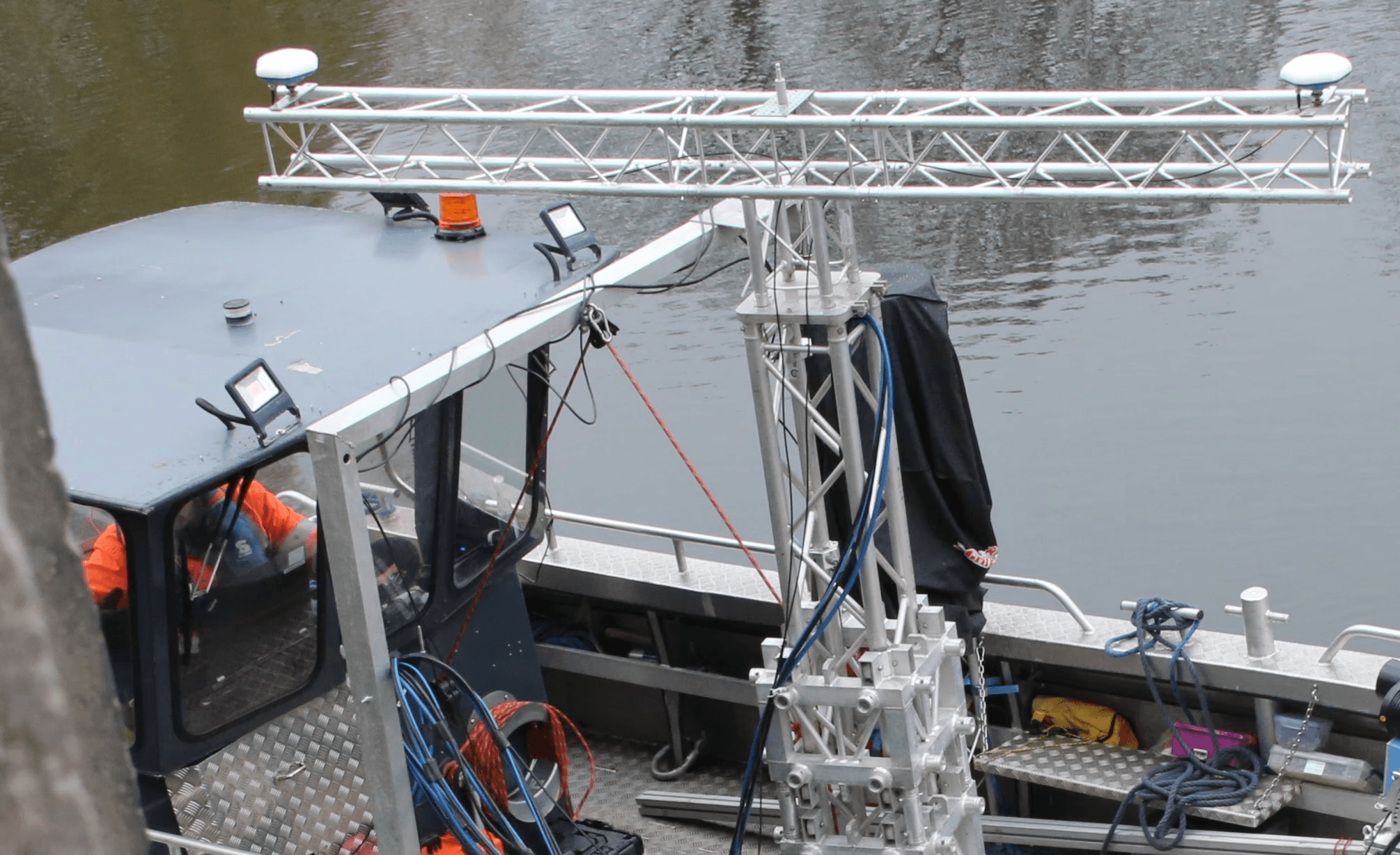
HydroScan combines state-of-the-art sensor technology with intelligent data processing. Thanks to our patented measurement methodology, even the smallest structures down to the sixth row of piles are captured. Automated processes allow HydroScan to significantly reduce both time and costs. Data acquisition is fast, contactless, and delivers maximum repeatability.

Service hause image

Versatile Applications

Whether dealing with quay walls, locks, pile groups, bridges, or weirs – HydroScan delivers reliable data for a wide range of engineering applications. Especially in hard-to-reach or safety-critical areas, this technology offers a clear advantage over conventional methods.

Precise Measurement Even Without GPS

For operations lacking reliable GPS reception, HydroScan offers a powerful alternative: patented tachymeter tracking. This technology enables exact positioning and data acquisition even in shielded or covered environments, such as under bridges, inside locks, or in tight harbor areas. Thanks to seamless integration into the overall system, measurement accuracy remains at the highest level at all times – completely independent of external signal conditions.


Data That Makes the Difference

The acquired measurement data is processed into user-friendly formats and can be seamlessly integrated into existing planning and analysis systems or the InfraCloud. Automated algorithms turn your data into actionable insights, transforming precise measurement into real added value for your project.

HydroScan – when underwater precision matters.

HydroScan - Patented Underwater Surveying Technology

With HydroScan, HydroMapper is setting new standards for the precise, efficient, and safe inspection of underwater structures.

HydroScan - Patented Underwater Surveying Technology

With HydroScan, HydroMapper is setting new standards for the precise, efficient, and safe inspection of underwater structures.

HydroScan - Patented Underwater Surveying Technology

With HydroScan, HydroMapper is setting new standards for the precise, efficient, and safe inspection of underwater structures.

HydroScan - Patented Underwater Surveying Technology

With HydroScan, HydroMapper is setting new standards for the precise, efficient, and safe inspection of underwater structures.

HD Mapping – High-Resolution 3D Capture of Surface Structures

By utilizing state-of-the-art camera systems and intelligent evaluation algorithms, we generate highly realistic 3D models with exceptional resolution.

HD Mapping – High-Resolution 3D Capture of Surface Structures

By utilizing state-of-the-art camera systems and intelligent evaluation algorithms, we generate highly realistic 3D models with exceptional resolution.

HD Mapping – High-Resolution 3D Capture of Surface Structures

By utilizing state-of-the-art camera systems and intelligent evaluation algorithms, we generate highly realistic 3D models with exceptional resolution.

Mobile Mapping – Millimeter-accurate 3D mapping of overwater structures

Our mobile mapping systems continuously capture spatial data as they move along the object or structure.

Mobile Mapping – Millimeter-accurate 3D mapping of overwater structures

Our mobile mapping systems continuously capture spatial data as they move along the object or structure.

Mobile Mapping – Millimeter-accurate 3D mapping of overwater structures

Our mobile mapping systems continuously capture spatial data as they move along the object or structure.

Mobile Mapping – Millimeter-accurate 3D mapping of overwater structures

Our mobile mapping systems continuously capture spatial data as they move along the object or structure.

HydroInspect – ROV-supported underwater inspection and documentation

HydroInspect ROV systems deliver crystal-clear visual data and sonar-based insights, even in low-visibility, turbid waters.

HydroInspect – ROV-supported underwater inspection and documentation

HydroInspect ROV systems deliver crystal-clear visual data and sonar-based insights, even in low-visibility, turbid waters.

HydroInspect – ROV-supported underwater inspection and documentation

HydroInspect ROV systems deliver crystal-clear visual data and sonar-based insights, even in low-visibility, turbid waters.

HydroInspect – ROV-supported underwater inspection and documentation

HydroInspect ROV systems deliver crystal-clear visual data and sonar-based insights, even in low-visibility, turbid waters.

AeroVision – Photogrammetric 3D Aerial Mapping

Aerial data acquisition enables fast and flexible documentation, even for large-scale or difficult-to-access structures.

AeroVision – Photogrammetric 3D Aerial Mapping

Aerial data acquisition enables fast and flexible documentation, even for large-scale or difficult-to-access structures.

AeroVision – Photogrammetric 3D Aerial Mapping

Aerial data acquisition enables fast and flexible documentation, even for large-scale or difficult-to-access structures.

AeroVision – Photogrammetric 3D Aerial Mapping

Aerial data acquisition enables fast and flexible documentation, even for large-scale or difficult-to-access structures.

InfraCapture 360 – Digital mapping of indoor spaces and industrial facilities

Whether it's industrial halls, production plants, engine rooms, technical infrastructure, or existing buildings – InfraCapture 360 is perfectly suited for highly structured environments.

InfraCapture 360 – Digital mapping of indoor spaces and industrial facilities

Whether it's industrial halls, production plants, engine rooms, technical infrastructure, or existing buildings – InfraCapture 360 is perfectly suited for highly structured environments.

InfraCapture 360 – Digital mapping of indoor spaces and industrial facilities

Whether it's industrial halls, production plants, engine rooms, technical infrastructure, or existing buildings – InfraCapture 360 is perfectly suited for highly structured environments.

InfraCapture 360 – Digital mapping of indoor spaces and industrial facilities

Whether it's industrial halls, production plants, engine rooms, technical infrastructure, or existing buildings – InfraCapture 360 is perfectly suited for highly structured environments.

Logo

Clone component

Copied to clipboard

+49 40 99 99 862-00

Veritaskai 6, 21079 Hamburg, Germany

Clone component

Copied to clipboard

info@hydromapper.de

© 2026 HydroMapper GmbH

Logo

Clone component

Copied to clipboard

+49 40 99 99 862-00

Veritaskai 6, 21079 Hamburg, Germany

Clone component

Copied to clipboard

info@hydromapper.de

© 2026 HydroMapper GmbH

Logo

Clone component

Copied to clipboard

+49 40 99 99 862-00

Veritaskai 6, 21079 Hamburg, Germany

Clone component

Copied to clipboard

info@hydromapper.de

© 2026 HydroMapper GmbH